
"The mountains are calling and I must go." - John Muir
Yes you must go and keep on going for these roads lead to a world of unbeliable wonder and beauty.
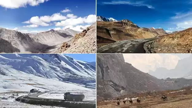
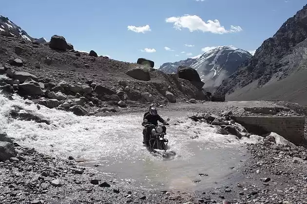
Any traveler would fail to deny the beauty and sernetiy of mountains in India. But when it comes to riding to the highest motorable roads in India, the journey speaks for itself. Imagine the thrill of driving along winding roads where the sky seems within arm's reach, the air is thinning and the landscape is ever changing like its all painted by your imagination. That's what these roads look like.
From Umling La, the highest motorable road in the world, to the historic Khardung La, each of these passes is more than just a route.
Once in a while be your own Ranchoddas Shamaldas Chanchad a.k.a. Phunsukh Wangdu from 3 Idiots and embark on a journey to self exploration on these highest motorable roads in India.
So buckle up and let your spirit of adventure soar !
What does 'La' in Tibetan mean?
As you embark on these journeys, you'll discover roads often referred to as "La," which means "pass" in Tibetan. The term "La" signifies the natural mountain passes that traverse the mighty Himalayan ranges, acting as conduits between valleys, towns, and people. Each pass, or La, carries with it a legacy of ancient trade routes and tales of brave explorers who dared to venture beyond the known.
Here are the 12 highest motorable passes in India
1. Umling La Pass
Location: Ladakh, Jammu and Kashmir
Height: 19,300 feet (5,883 meters)
Difficulty: Extremely challenging
Road Condition: Rough and rugged, with sections of loose gravel and sharp rocks
Scenic Beauty: Panoramic views of barren mountains and vast valleys, offering an otherworldly experience

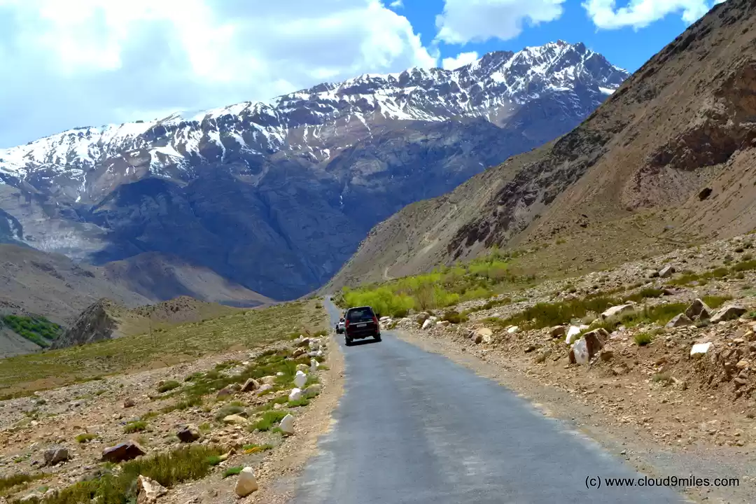
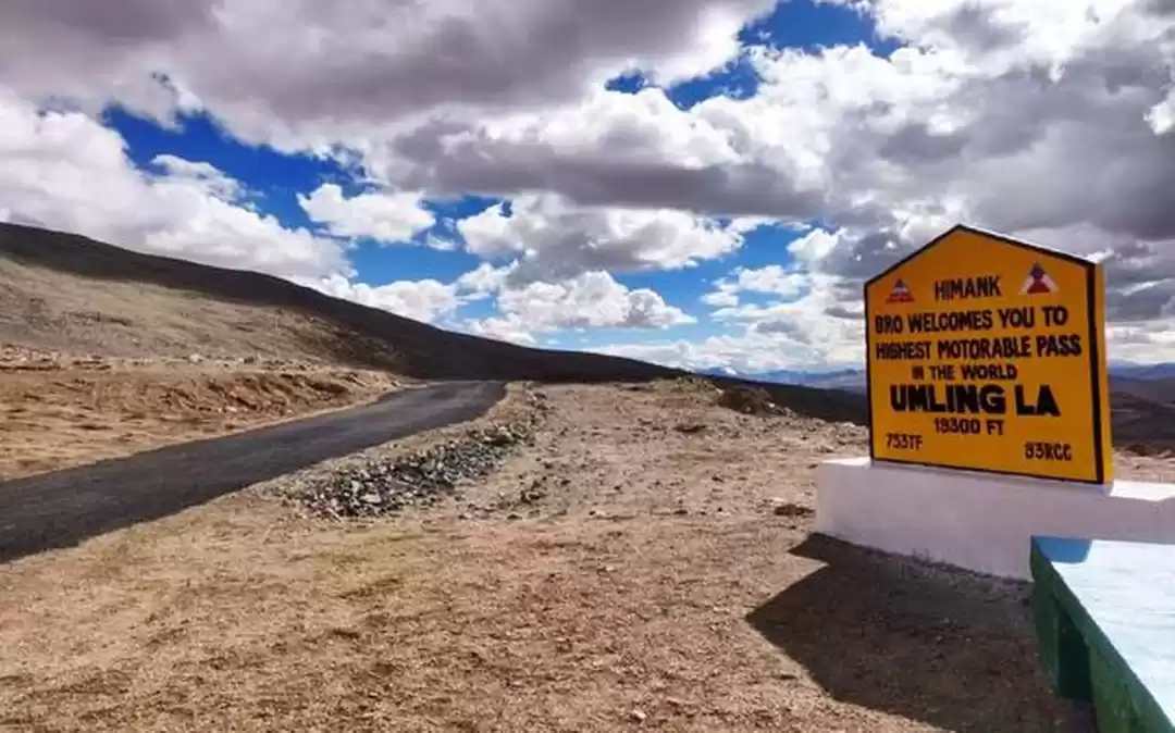
Standing at an astonishing altitude of 19,300 feet, Umling La is the highest motorable road in the world, and reaching its summit is akin to touching the sky.
The journey to Umling La begins in the remote village of Hanle, known for its astronomical observatory. From here, the road , built by the Border Roads Organisation (BRO) climbs sharply, winding through some of the most desolate and rugged terrains on the planet. And as you move forwar and upward, the air starts thinning rapidly making even the simplest tasks feel herculean.
Upon reaching Umling La, you are rewarded with views that are simply out of this world. The pass offers a 360-degree panorama of the surrounding Himalayan peaks, each standing tall in silent majesty. The sky here seems closer, more vivid, and the play of light on the snow-capped peaks creates a spectacle that defies description.

At Umling La, you might find small cairns and prayer flags left by previous travelers, adding a spiritual layer to the stark landscape. You can also add one of yours as a forever memory with Umling La.
Permit Required: Inner Line Permit (ILP) from the District Magistrate's office in Leh.
How to Obtain: Apply in person or through a travel agency with a copy of your ID and vehicle registration documents. The permit is usually issued within a few days.
Road Trips Requiring Umling La Pass:
Hanle to Demchok - Distance: 105 km, Time Required: 4-5 hours
Hanle to Umling La Circuit - Distance: 80 km, Time Required: 3-4 hours
Visit Ladakh Tripoto style
Plan your trip now!
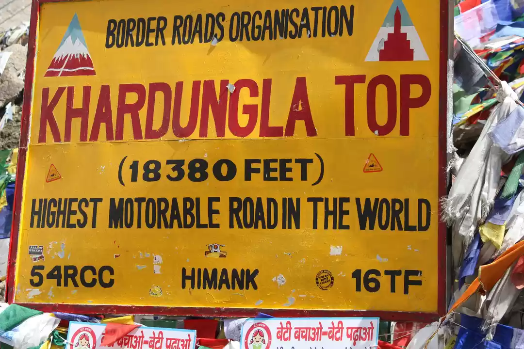
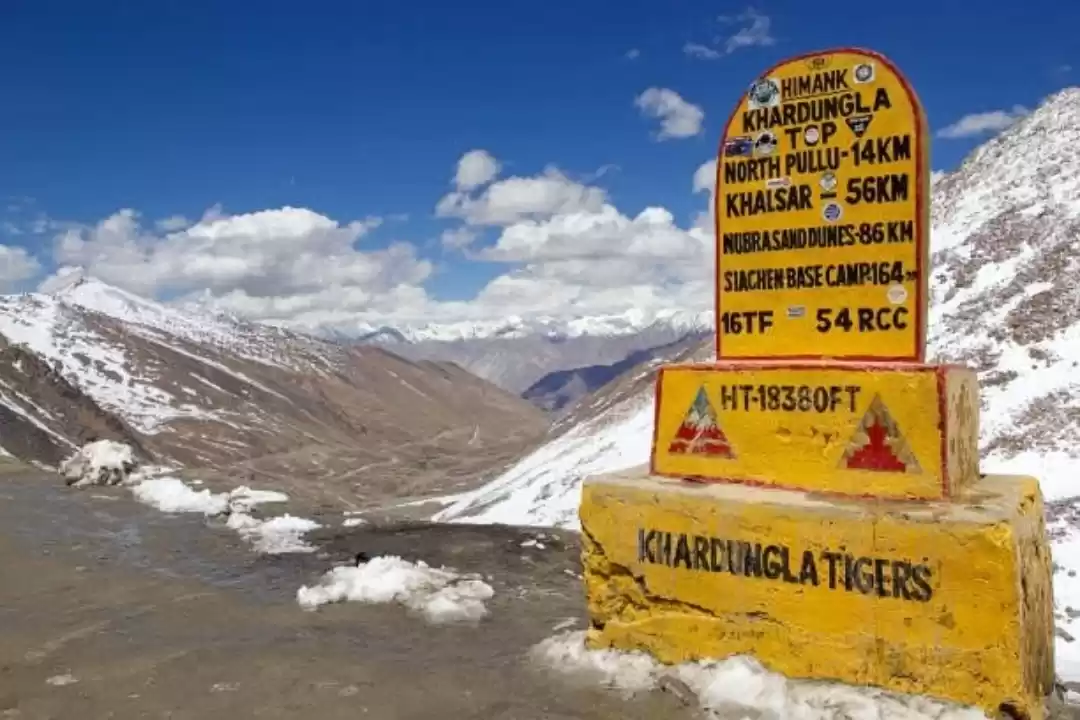
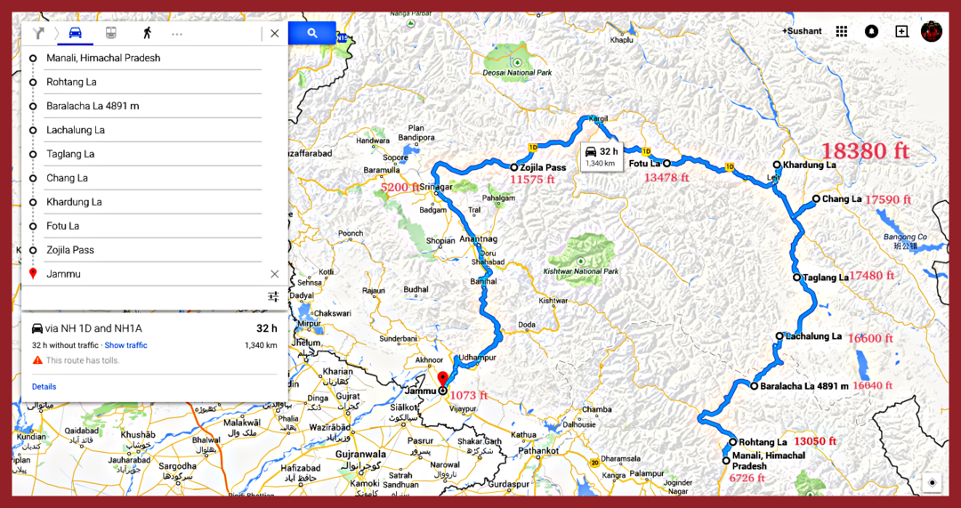
2. Khardung La
Location: Ladakh, Jammu and Kashmir
Height: 18,380 feet (5,602 meters)
Difficulty: Very challenging
Road Condition: Rough, with steep ascents and descents, often covered in snow and ice
Scenic Beauty: Awe-inspiring views of the Karakoram Range and the Indus Valley, with an exhilarating sense of achievement

Nestled in the mighty Himalayas, Khardung La stands as one of the most celebrated high-altitude mountain passes in the world.
Khardung La holds strategic importance as it was once part of the ancient caravan route that connected Leh to Kashgar in Central Asia. This historical route was used by traders carrying goods like silk, spices, and other treasures, making it a vital artery for commerce and cultural exchange.
Known as the Gateway to the Nubra and Shyok Valleys, the drive to Khardung La is definitely not for the faint hearted ones.
Starting from Leh, the road twists and turns, ascending steadily through barren landscapes dotted with monasteries and fluttering prayer flags of all colors.
As you climb higher, the air gets thinner, and the road gets often rugged, with patches of loose gravel and occasional streams cutting across.
At Khardung La, you are greeted with panoramic views of the Ladakhi terrain. The sight of endless mountain ranges, with their peaks shimmering under the sunlight, is a visual of a lifetime
Permit Required: No special permit required for Indian tourists. Foreign tourists need to obtain a Protected Area Permit (PAP) or Restricted Area Permit (RAP) from the District Magistrate's office in Leh.
How to Obtain: Apply in person with a copy of your passport and visa. The permit is usually issued on the same day.
Road Trips Requiring Khardung La:
Leh to Nubra Valley - Distance: 120 km, Time Required: 4-6 hours
Leh to Siachen Base Camp - Distance: 270 km, Time Required: 8-10 hours
3. Chang La
Location: Ladakh, Jammu and Kashmir
Height: 17,590 feet (5,360 meters)
Difficulty: Moderate to challenging
Road Condition: Generally well-maintained but can be treacherous during snow and rain
Scenic Beauty: Stunning views of snow-capped peaks, alpine meadows, and crystal-clear streams

Embarking on the journey to Chang La, one of the Highest Motorable Roads In India is akin to stepping into a world of snow-capped wonder and serene mystique high up in the valley of Ladakh. Known as the "Pass to the North," Chang La serves as the gateway to the picturesque Pangong Lake. It was also a part of the ancient silk route, facilitating trade and cultural exchange between India and Tibet.
Starting your journey from the vibrant town of Leh, the road to Chang La meanders through scenic valleys and quaint and quiet hamlets, gradually entering the Ladakhi terrain. The journey is dotted with gushing streams, verdant meadows, and the occasional glimpse of local wildlife, making the drive an adventure in itself.
The ascent to Chang La is steep, with narrow roads that require careful navigation. The pass is often blanketed in snow, adding to the thrill and challenge of the journey.
Reaching the top of Chang La, you are greeted by a panoramic view that stretches endlessly. At Chang La, visit the small shrine dedicated to the guardian deities stands as a symbol of protection and faith. Do visit the site and conclude your expedition with fulfillment
Permit Required: Same as Khardung La
How to Obtain: Same as Khardung La
Road Trips Requiring Chang La:
Leh to Pangong Tso - Distance: 160 km, Time Required: 5-6 hours
Leh to Tangtse to Pangong Lake - Distance: 150 km, Time Required: 5-6 hours
Check these 10 Road Trips to Cover All of India by Tripoto traveler
4. Tanglang La
Location: Ladakh, Jammu and Kashmir
Height: 17,480 feet (5,328 meters)
Difficulty: Moderate
Road Condition: Paved but can be challenging due to altitude and weather conditions
Scenic Beauty: Sweeping vistas of the Zanskar Range and remote high-altitude plains

Often referred to as the Gateway to Leh, Tanglang La is a high mountain pass in Ladakh and is a part of the most famous roadtrip route in India, i.e. thorugh the Leh-Manali Highway, making it a sought-after destination for thrill-seekers and nature lovers alike.
Tanglang La has been a crucial link in the trade routes connecting the Indian subcontinent with Central Asia. The road to Tanglang La take you through some of the the most stunning landscapes in Ladakh. As you ascend, the barren beauty of the high-altitude desert gives way to snow-covered peaks and winding roads that seem to stretch endlessly into the sky.
Navigating Tanglang La is no small feat. The road can be treacherous, with sharp bends, steep inclines, and patches of rough terrain. The high altitude adds to the challenge, making every breath feel precious.
At the top of Tanglang La, the view is nothing short of ethereal. The summit of Tanglang La is marked by the presence of prayer flags and small stupas, symbols of spiritual protection and blessings.
Permit Required: Same as Khardung La
How to Obtain: Same as Khardung La
Road Trips Requiring Tanglang La:
Leh to Manali- Distance: 480 km, Time Required: 15-18 hours (split over two days)
Leh to Sarchu- Distance: 260 km, Time Required: 8-10 hours
5. Marsimik La
Location: Ladakh, Jammu and Kashmir
Height: 18,953 feet (5,777 meters)
Difficulty: Very challenging
Road Condition: Mostly unpaved, with steep gradients and loose gravel
Scenic Beauty: Majestic views of rugged mountains and the Changthang Plateau

Situated near the Pangong Tso, Marsimik La, often dubbed as the Mecca for Off-Roaders, stands as a testament to the unyielding spirit of adventure and exploration.
The journey to Marsimik La begins at the serene Pangong Tso, with its crystal-clear blue waters providing a stark contrast to the rugged, arid landscape. The road is less traveled, often rugged and treacherous, with loose gravel and sharp bends.
At the summit of Marsimik La, the view of the vast expanse of the Himalayas stretches out in every direction, with the peaks standing tall and proud against the sky. The landscape is a study in contrasts I must say.
While Marsimik La itself is remote, the journey offers glimpses into the rich cultural tapestry of Ladakh. The region is dotted with small villages, ancient monasteries, and prayer flags fluttering in the wind, adding a spiritual dimension to the adventure.
Permit Required: Inner Line Permit (ILP) from the District Magistrate's office in Leh.
How to Obtain: Apply in person or through a travel agency with a copy of your ID and vehicle registration documents. The permit is usually issued within a few days.
Road Trips Requiring Marsimik La:
Pangong Tso to Marsimik La - Distance: 42 km, Time Required: 2-3 hours
6. Sela Pass
Location: Arunachal Pradesh
Height: 13,700 feet (4,170 meters)
Difficulty: Moderate
Road Condition: Generally well-maintained, but snow and ice can make it slippery
Scenic Beauty: Stunning views of snow-clad peaks, pristine lakes, and vibrant prayer flags fluttering in the wind

Hidden amidst the mystical eastern Himalayas, Sela Pass is not just a road but a portal to an ethereal world of the North Eastern India where nature’s beauty reigns supreme.
It was a strategic route during the 1962 Sino-Indian War and remains a vital link for the Indian Army. The pass is also steeped in local legends, with tales of monks and warriors adding to its mystical allure of Sela Pass.
Known as the Guardian of Serenity, this pass connects the town of Tawang with the rest of Arunachal Pradesh and offers an unforgettable journey through one of India’s most stunning landscapes.
The ascent to Sela Pass begins from Bomdila, winding through lush forests, picturesque valleys, and cascading waterfalls. The road, a ribbon of asphalt that threads its way through this pristine wilderness, takes you higher and higher, each turn revealing a new facet of nature’s artistry.

At the summit of Sela Pass, you will be greeted by the sight of the Sela Lake. The lake, often frozen in winter, reflects the surrounding mountains in its pristine waters, creating a picture-perfect tableau.
The pass is dotted with small shrines and stupas, and the most prominent is the Sela Temple, a small but sacred site where you can stop and imbibe the peace within.
Permit Required: Same as Khardung La
How to Obtain: Same as Khardung La
Road Trips Requiring Sela Pass:
Guwahati to Tawang - Distance: 520 km, Time Required: 14-16 hours
Tezpur to Tawang - Distance: 330 km, Time Required: 10-12 hours
Do you love North East? Check these 5 Epic Road Trips In North-East India by Tripoto traveler
7. Zoji La
Location: Jammu and Kashmir
Height: 11,575 feet (3,528 meters)
Difficulty: Moderate
Road Condition: Paved but narrow and prone to landslides
Scenic Beauty: Dramatic landscapes featuring lush green valleys and towering mountains

Strategically, Zoji La holds immense importance for India and is one of the Highest Motorable Roads In India and also one of the most adventurous as well. It has been a critical point of focus during various military operations, particularly during the Indo-Pakistani wars.
Zoji La, the Gateway of Adventure, is more than just a mountain pass. Starting from Srinagar, the journey to Zoji La takes you through some of the most picturesque landscapes in India.
he route begins in the lush, green valleys of Kashmir, passing through the charming town of Sonamarg, known as the 'Meadow of Gold.' As you approach Zoji La, the scenery transforms dramatically. The verdant meadows give way to stark, rugged mountain terrains, and the air becomes crisper and cooler.

Needless to say, the road is equally challenging just like Khardung La along with a combination of arrow pathways and unpredictable weather.
Despite its challenging nature, Zoji La offers some of the most spectacular vistas. Wildlife enthusiasts might spot Himalayan marmots, snow leopards, and various bird species along the way. The Dras Valley, located near Zoji La, is another point of interest. Known as the Gateway to Ladakh, Dras is often cited as one of the coldest inhabited places in the world.
Permit Required: Same as Khardung La
How to Obtain: Same as Khardung La
Road Trips Requiring Zoji La
Srinagar to Leh - Distance: 434 km, Time Required: 10-12 hours
Sonamarg to Dras to Kargil -Distance: 120 km, Time Required: 4-5 hours
If you have that adventurous soul the check these 8 deadliest roads in India for the ultimate thrill
8. Baralacha La
Location: Himachal Pradesh
Height: 16,040 feet (4,890 meters)
Difficulty: Challenging
Road Condition: Rough terrain with patches of snow and ice
Scenic Beauty: Panoramic vistas of rugged mountains, shimmering lakes, and vast expanses of snow

Situated on the Leh-Manali Highway, Baralacha La is a confluence of paths, histories, and breathtaking vistas. The road to Baralacha La is a journey through some of the most spectacular scenery in the Himalayas. Starting from the lush valleys of Manali, the road climbs steadily through verdant forests and meandering rivers, ascending towards the high-altitude desert of Ladakh.
Each mile brings a change in the landscape, from the greenery of Himachal Pradesh to the stark, rugged beauty of the high Himalayas. It connects the valleys of Lahaul in Himachal Pradesh with the Zanskar region of Ladakh, making it a vital link for commerce and communication. you can also visit the Kang La pass connecting Lahaul to Ladakh.

Driving to Baralacha La is a thrilling adventure. The road is steep and winding, often covered in snow and ice, making the journey both challenging and exhilarating.
At the summit of Baralacha La, the view is nothing short of magnificent. The pass is surrounded by towering peaks, their snow-capped summits glistening in the sunlight. Two pristine lakes, Suraj Tal and Deepak Tal, add to the beauty, their turquoise waters reflecting the surrounding mountains.
Permit Required: Same as Khardung La
How to Obtain: Same as Khardung La
Road Trips Requiring Baralacha La:
Manali to Leh - Distance: 474 km, Time Required: 15-18 hours over two days
Jispa to Sarchu - Distance: 85 km, Time Required: 2-3 hours
9. Rohtang Pass
Location: Himachal Pradesh
Height: 13,050 feet (3,978 meters)
Difficulty: Moderate to challenging
Road Condition: Paved but prone to landslides and traffic jams
Scenic Beauty: Majestic views of the Pir Panjal Range, lush green valleys, and cascading waterfalls

Whether been to Himachal Pradesh or not, we all have heard of the famous Rohtang Pass. Often referred to as the Gateway to Lahaul-Spiti, Rohtang Pass, whose name means "pile of corpses" in Tibetan, referring to the numerous lives claimed by its treacherous conditions over the years, is part of the Pir Panjal Range of the Himalayas
The road to Rohtang Pass starts from the bustling town of Manali, winding its way through lush forests of deodar and pine and is approximately 51 kilometers long.
The first stretch of the journey takes you from Manali to Marhi, a small settlement known for its roadside eateries and picturesque views. Then the final journey from Marhi to Rohtang Pass is a steep climb through rugged and often snow-covered terrain.

At the summit of Rohtang Pass, it offers a panoramic vista of the Himalayas, with the lush green Kullu Valley on one side and the stark, rugged beauty of the Lahaul-Spiti Valley on the other. A key highlight of this region is the Beas Kund. A short trek from Rohtang Pass leads to Beas Kund, a glacial lake that is the source of the Beas River.
Permit Required: Indian tourists need to obtain a permit from the Rohtang Pass Permit Issuing Authority. Foreign tourists need to obtain a permit from the District Magistrate's office in Manali.
How to Obtain: Permits can be applied for online or in person at the respective offices. The permit is usually issued within a few days.
Road Trips Requiring Rohtang Pass:
Manali to Leh - Distance: 474 km, Time Required: 15-18 hours over two days
Manali to Spiti Valley - Distance: 200 km to Kaza, Time Required: 10-12 hours
10. Nathu La
Location: Sikkim
Height: 14,140 feet (4,310 meters)
Difficulty: Moderate
Road Condition: Well-paved but can be slippery due to snow and rain
Scenic Beauty: Breathtaking views of the Eastern Himalayas, lush green valleys, and historic sites

Nathu La, meaning Listening Ears Pass, stands as a serene sentinel on the border between India and China, weaving together tales of history, spirituality, and breathtaking natural beauty.
Nathu La is part of the Eastern Himalayas and lies on the ancient Silk Route, which once facilitated trade between India and Tibet. The pass is located approximately 54 kilometers east of Gangtok, the capital of Sikkim. Historically, Nathu La has been a significant trade route, enabling the exchange of goods such as silk, tea, and wool between India and Tibet.
Your journey to Nathu La begins from the bustling town of Gangtok, guiding you to the Tsomgo Lake located at an altitude of 12,313 feet.

From Tsomgo Lake, the journey continues upward to Nathu La Pass. The road becomes steeper and more challenging as you ascend, with hairpin bends and narrow pathways adding to the thrill. Located near Nathu La, this shrine is dedicated to Baba Harbhajan Singh, a soldier of the Indian Army who is revered as a saint.
Permit Required: Indian tourists need to obtain a permit from the Sikkim Tourism Office in Gangtok. Foreign tourists are not allowed to travel beyond Tsomgo Lake.
How to Obtain: Apply in person with a copy of your ID proof and two passport-sized photographs. The permit is usually issued on the same day.
Road Trips Requiring Nathu La Pass:
Gangtok to Nathu La - Distance: 56 km, Time Required: 2-3 hours
Gangtok to Tsomgo Lake - Distance: 38 km, Time Required: 1-2 hours
11. Fotu La
Location: Ladakh, Jammu and Kashmir
Height: 13,478 feet (4,108 meters)
Difficulty: Moderate
Road Condition: Generally good, with some rough patches
Scenic Beauty: Expansive views of barren mountains, deep gorges, and high-altitude deserts

Fotu La, the highest point on the Srinagar-Leh Highway, is the ultimate resort where serenity meets grandeur. This mountain pass, often referred to as the Roof of Serenity, offers travelers a unique blend of breathtaking landscapes, challenging roads, and a sense of profound peace.
The road to Fotu La begins in the lush valleys of Srinagar, where each twist and turn offers a new perspective on the rugged beauty of the Himalayas. From Kargil, the road ascends steeply towards Fotu La, passing through rugged and barren landscapes. The ascent is gradual but challenging, with numerous hairpin bends and sharp turns.

The pass offers panoramic views of the surrounding Himalayan peaks, including the majestic Nun Kun massif. The landscape is dotted with colorful wildflowers during the summer months, adding a touch of vibrancy to the otherwise stark surroundings.
For a long time, Fotu La has long been a crucial link in the trade routes connecting the Kashmir Valley with Ladakh as well.
Permit Required: Same as Khardung La
How to Obtain: Same as Khardung La
Road Trips Requiring Fotula:
Srinagar to Leh - Distance: 434 km, Time Required: 10-12 hours
Kargil to Leh - Distance: 216 km, Time Required: 4-6 hours
12. Kunzum Pass
Location: Himachal Pradesh
Height: 15,059 feet (4,590 meters)
Difficulty: Challenging
Road Condition: Rough and unpaved, with steep ascents and descents
Scenic Beauty: Spectacular views of the Spiti Valley, towering peaks, and pristine glaciers

Kunzum Pass is the Gateway to Spiti where the rugged beauty of the Himalayas meets the spiritual serenity of ancient cultures. Kunzum Pass is situated in the eastern Kunzum Range of the Himalayas and connects the Kullu Valley with the Spiti Valley.
Historically, Kunzum Pass has been a vital trade route between the regions of Lahaul, Spiti, and Tibet, facilitating the exchange of goods and culture between India and Tibet.
The road to Kunzum Pass begins in the lush valleys of Manali, climbing steadily through verdant forests and picturesque villages. From Rohtang Pass, the road winds through the picturesque Lahaul Valley, passing through quaint villages and alongside glistening rivers. From Batal, the road ascends steeply towards Kunzum Pass, offering panoramic views of the surrounding mountains and valleys. The final stretch of the journey is a thrilling yet challenging drive, with narrow roads and steep drops.

Located near Kunzum Pass, Key Monastery is one of the oldest and largest monasteries in the Spiti Valley and is a must visit on your visit to Kunzum.
At the top of Kunzum Pass stands the Kunzum Devi Temple, a small but significant shrine dedicated to the local goddess. The pass is also adorned with colorful prayer flags, fluttering in the wind and carrying prayers across the mountains.
Permit Required: Same as Khardung La
How to Obtain: Same as Khardung La
Road Trips Requiring Kunzum Pass:
Manali to Spiti Valley - Distance: 200 km to Kaza, Time Required: 10-12 hours
Kaza to Keylong - Distance: 190 km, Time Required: 8-10 hours
Tips for Visiting the Highest Motorable Roads in India
Visiting the highest motorable passes in India is an exhilarating adventure, but it requires careful planning and preparation. Here are some tips for you on your ride to these motorable roads in India
- Spend Time at Lower Altitudes: Before heading to high-altitude passes like Umling La, Khardung La, and Marsimik La, spend a few days at lower altitudes (e.g., Leh or Manali) to help your body adjust to the reduced oxygen levels.
- Gradual Ascent: Avoid rapid ascents to minimize the risk of altitude sickness. Increase elevation gradually to give your body time to adapt.

- Hydrate: Drink plenty of water to stay hydrated. Dehydration can exacerbate altitude sickness.
- Vehicle Check: Ensure your vehicle is in excellent condition. Check brakes, tires, and fluid levels.
- Carry Spare Parts: Bring essential spare parts, such as extra tires, coolant, and engine oil, as help may not be readily available in remote areas.
- Fuel Up: Fill up your tank whenever possible, as fuel stations can be scarce at high altitudes.
- Warm Clothing: Pack layers of warm clothing, including thermal wear, as temperatures can drop significantly at high altitudes.
- Medical Supplies: Carry a first-aid kit, including altitude sickness medication, pain relievers, and any personal medications.
- Oxygen Cylinders: Consider carrying portable oxygen cylinders, especially for higher passes like Umling La and Marsimik La, where oxygen levels are very low.
- Weather Forecast: Monitor weather conditions closely. Snowfall and landslides can make roads impassable.
- Road Updates: Check for road conditions and closures. Local authorities or travel forums can provide the latest updates.
- Obtain Permits: Secure necessary permits well in advance. Passes like Umling La and Marsimik La are in restricted areas requiring special permits.
- Carry Documents: Keep multiple copies of permits, ID proofs, and vehicle documents.
- Avoid Night Driving: Refrain from driving at night due to poor visibility and increased risk of accidents.


' fill='%23359391'%3e %3cpath d='M46.1538462%2c43.5714286 L41.5%2c50 L36.8461538%2c43.5714286 L36.8670256%2c43.5714286 C36.3173077%2c42.7142857 36%2c41.6851429 36%2c40.5714286 C36%2c37.4854286 38.4535641%2c35 41.5%2c35 C44.5464359%2c35 47%2c37.4854286 47%2c40.5714286 C47%2c41.6851429 46.6826923%2c42.7142857 46.1329744%2c43.5714286 L46.1538462%2c43.5714286 Z M41.4294872%2c39 C40.6150641%2c39 39.9487179%2c39.675 39.9487179%2c40.5 C39.9487179%2c41.325 40.6150641%2c42 41.4294872%2c42 C42.2439103%2c42 42.9102564%2c41.325 42.9102564%2c40.5 C42.9102564%2c39.675 42.2439103%2c39 41.4294872%2c39 L41.4294872%2c39 Z' id='Location-white'%3e%3c/path%3e %3c/g%3e %3c/svg%3e)